
project
EPIC Fellowship
Ten weeks at the California State Water Board — mapping water data, the energy nexus, and a sense of purpose.
Wastewater Treatment Facilities & Combined Heat & Power Storymap
PART I: Finding Myself
As I reflect on my ten-week Environmental Policy Internship (EPIC) at the California State Water Board, I’m struck by how much I’ve learned, not just about water and data systems, but about myself. When I first began applying for internships back in December of 2025, I felt like my time spent inside the classroom had fueled a desire to apply my conceptual studies into real-world systems, yet I lacked direction for where to channel that momentum. By then I had just completed my first quarter of college, and what shocked me was how much I had pivoted in my academic and professional journey in such little time. For instance, it only took a single one-unit course called the Explore Energy Seminar to convince me that adopting a deep interest in energy systems was worthwhile for me. What I loved most about that class, which I later learned applied to the energy field as a whole, was each week our instructor, Dr. Holmes, invited an individual or a group of people to talk about their line of work in a single subdomain of energy. We heard from researchers working on cutting-edge battery technologies, listened to geospatial experts who help plan giga-scale infrastructure projects, conversed with consultants who analyze data to steer policy decisions, and met with entrepreneurs who’ve founded companies in the clean energy space. These glimpses into the multi-faceted and actively evolving nature of energy shined a light on just how interdisciplinary and intellectually challenging the field was and it was this web of ideas, practitioners, modern challenges, and ripe opportunities that drew me in. Thus, the hunt for a summer position that could propel my ambitions began.
Before applying to my position at the California State Water Board, I frankly didn’t know about its existence. In fact, it was only after taking a handful of policy courses at Stanford did I learn about state agencies such as the California Public Utility Commission (CPUC), the California Energy Commission (CEC), or the California Independent System Operator (CAISO) and their often unrecognized, yet essential efforts to maintain the public systems we all rely on. In the modern zeitgeist, it’s often prominent billion-dollar companies that garner the lion’s share of recognition and credit for society’s forward progress, but what rarely gets talked about are the talented and hardworking professionals working at government agencies who do the tough diligence of weighing the needs and wants of all stakeholders to then propose, debate, and implement, policy and regulatory structures that facilitate an ecosystem on top of which companies can fairly compete and thrive. In the end, it’s great work being done by good people at federal, state, and local agencies that allow for impactful opportunities to rise through, and whatever my future holds, I hope to do well to never forget this truth. I’m grateful to my mentor Anna Holder, and my collaborators Greg Gearheart and Andrew Hamilton, for guiding me through my time here, and I extend my deepest appreciation to all the people I’ve had a chance to connect with and for the wisdom they’ve imparted with me.
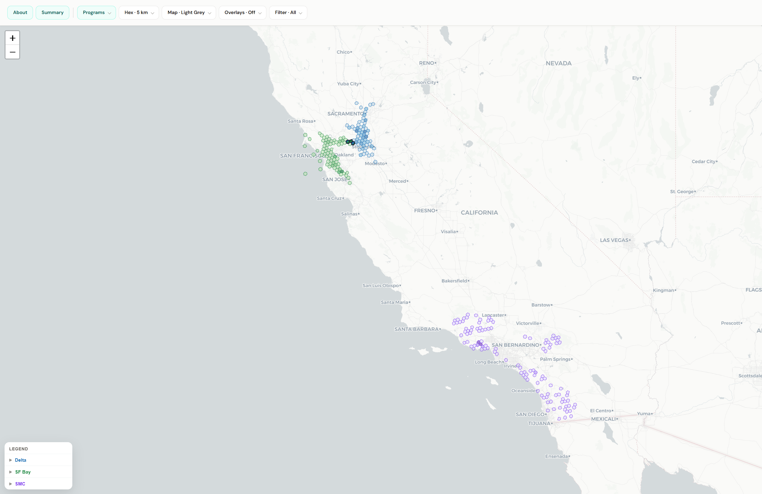
At the onset of this internship, I half-expected to get instructed to learn a data-related technical skill so I could fit into some active work operation, but to my pleasant surprise, my mentor made it clear that this internship was mine to shape and I could take it as far as I wanted to with no pre-defined expectations of what I had to do. With this, I had a rare chance to design my own projects centered around my interests, leading to me to develop a map of the station footprint of six Regional Monitoring Programs with high data transparency, and later conduct an analysis that bridged the water-energy nexus together where I examined which wastewater treatment plants in California have the potential to adopt combined heat and power (CHP) systems to recoup energy from what otherwise would be wasted biogas. Both projects involved a nuanced understanding of data sourcing, cleaning, and interpreting what can and can’t be reasonably inferred from the data, and by using my programming and digital skills, including the responsible use of AI, I produced two final products that were polished and had value.
While it’s hard to gauge what it felt like in the moment, looking back on it now I’m proud of the work I’ve accomplished from both a technical perspective and in the human skills I’ve practiced. Most of all, however, I feel like this ten week experience has allowed me to articulate a sense of purpose for myself in where I want to go from here. Throughout my life, I’ve continually been in awe of the power that digital systems can have to help turn messy data into clear and repeatable processes. Starting with simple spreadsheet formulas I coded in high school, to writing custom python scripts, to now building a geospatial analysis platform from scratch, what underlies all these efforts is this: I want to leverage my digital skills to help people make sense of the data around us because that will allow people to make better decisions that benefit the collective. That’s what I feel like I’ve been quietly pursuing for years now without knowing it, and finally, this summer internship has helped me gain clarity for where I wish to channel this vision. Beyond any piece of knowledge or skill that I learned, this sense of direction, this fire that’s been lit under me, might be the best gift this opportunity has offered me.
PART II: My Practices With Data & Digital Systems
The first work product I engaged in originated from an exploratory lens with the idea that I’d ease my foray into the State Water Board’s data systems by developing a holistic understanding of data management with a low-stakes, yet still end-to-end, project. I spent time playing with data portals, combing through metadata, and downloading .xls files to get a sense of what I was working with. I learned about how the State Water Board oversees nine Regional Water Boards and heard about the complexities of aggregating local data from independent organizations, institutes, research labs, and paid studies to answer key questions around beneficial uses and water quality. I got a chance to read through parts of the Integrated Report—an essential data report that covers all watersheds—talk to individuals closely involved in its development, and hear about the frustrations of a six-year delivery cycle and how automated scripts have only recently been introduced to help. Through my check-ins with my mentors in the early weeks, we eventually settled in on the scope of my first project: familiarizing myself with six Regional Monitoring Programs (RMPs) and pull data from the California Environmental Data Exchange Network (CEDEN) to map out the station footprint of each program in a single map. What I quickly learned is that the data we want is rarely, if ever, neatly packaged as the data we get, and I discovered first-hand the messiness of interacting with public data systems.
Although CEDEN was an intuitive data portal for which I could filter and pull useful datasets from, often the data itself might be stale, uncleaned, or lacked descriptive metadata. For Delta RMP, Stormwater Monitoring Coalition (SMC) program, and San Francisco Bay RMP, the data I found using CEDEN proved to be ready to be cleaned and ingested into the map. But for Klamath Basin RMP, for example, the data found in CEDEN was outdated compared to the CSV file of the station data found directly on their website so I pivoted to using that instead. Similarly, the Russian River RMP didn’t have useful station data in CEDEN so I pivoted to using the wetland polygons geopackage found on their website and translating that into the H3 hexagon format my map used. As illustrated above, even with only six programs, the data collection methods and quality varied which made the need for rigorous documentation and transparency even greater. As I recorded each step I took to collect the data, I updated the ReadMe to reflect the nuances of retrieving each dataset and focused on considering how to make it as intuitive as possible for another person to understand why and what I did.
My understanding of the challenges with data systems only grew through my one-on-one conversations with professionals working in the state and regional Water Boards. Issues around data quality, data relevancy, and data management would become recurrent themes in my conversations. I was shocked to hear that the water board uses over 60 enterprise software systems, with the need to consolidate and collapse many of them remaining an ongoing pursuit within the organization. Or how within a single data product, the raw inputs might have dozens of unique data schemas that have to be inspected, managed, and collected in a way that yields defensible insight from them. Or how historical legislation and funding pressures have emphasized the collection of chemical and toxicological water data, while biological data that tells us what actually lives here, can get overlooked in some watersheds. These, and countless other examples, have instilled in me the value of being attentive to the data that gets presented to us, and to examine things beyond the exterior of what it’s presented as. The more research, the more context I could gather for a dataset, the better off I was at making decisions around its credibility, pertinence, and usefulness. The RMP Map I created felt like a culmination of these small learnings I adopted even if they didn’t show it directly. The revisions I made to it reflected the underlying value of attentiveness that I’m acutely aware of now, and I hope future interns will be able to build upon the work that I’ve done.
In the final few weeks of my internship, inspired by my conversation with Chair Esquival, I moved on to conduct an analysis of wastewater treatment plants within California that had the potential to upgrade to combined heat & power systems which would generate electricity from what otherwise would be wasted heat. What was unique about this analysis was that in lieu of using traditional tools like ArcGIS Pro or ArcGIS Storymap, I opted to create my final product within a platform that I’d been vibecoding as a side-project that I started this summer. My motivation to build my own geospatial platform originated from a course I took earlier in spring called Spatial Planning for Giga-scale Renewables and Transmission. In that course we were paired with community partners who were professionals such as county planners, environmental advocates, and other public service individuals who dealt with and relied on geospatial maps to make decisions that could start or stop million-dollar infrastructure projects. There, I saw firsthand how a map I made using ArcGIS Pro could be used by my community partner that day to help them in their work meetings and by seeing this direct connection between my newfound expertise in mapping software and the value they got from it, I decided to build a more intuitive, modern, browser-based version of ArcGIS Pro with better tooling and features that I wanted to see, but wasn’t in the software we used.
Initially, I expected that the work I did at the California State Water Board would stay distinct from the geospatial platform, but after realizing just how interconnected spatial datasets were with water quality, and given the scope of the analysis project, a natural harmony emerged where I could use the platform I was building to run the analysis and in doing so, I could test features out, and develop additional tools to help with my particular task while improving the platform as a whole. In essence, I was the lead developer and my own first user of this platform, and I was continually surprised by not only the extent of what digital software could do, but the ease at which I, alongside Cursor—an AI powered coding platform—could develop it rapidly. By having total control over the features I needed, I replicated ArcGIS Storymaps within the geospatial platform, made finding and citing web sources and pdf documents streamlined, and allowed for the final Storymap product to be exportable as a standalone code repository that could be hosted on Github Pages for free.
Although my intent for building this geospatial platform is so that everyday people can access and build maps of their own without the technical barrier of using ArcGIS Pro, it’s important to acknowledge the non-trivial environmental impacts that data centers which train and host AI services have and my usage of them. While it’s unclear what my exact ecological footprint building this platform was since environmental impact figures are often hidden from the public eye, there are numerous learnings I’ve had regarding the responsible use of AI with data and in building software itself that I’d like to share. For one, on the data side, the analysis that I conducted only dealt with publicly accessible data found on the internet, and thus I didn’t have nor need access to datasets with personally identifiable information. However it’s critical to take precautions around data privacy and data usage since people can grant AI systems to entire file systems within our computer so being careful about which folders a system like Cursor has access to is paramount. Ensuring that the agents can only see and modify what it needs and verifying terminal-based commands before they execute are just some security practices to adopt. Just this sumer, the Stanford Doer School of Sustainability issued their own policies surrounding the use of Agentic AI tools, which acknowledges the trend that using AI to build software services will likely accelerate, and thus the need for individuals to become aware of the best security and privacy practices will grow.
On another note, there’s a difference between using AI to build deterministic software, such as what I’m doing by using Cursor to build a geospatial platform, versus building or using AI systems to directly engage with data in a blackbox format which is what LLM’s and other AI models do. From the start, I was explicit about wanting to use AI to build deterministic software, and not trying to build or use AI models to directly engage with spatial or semantic data in an unknown way. I later used API calls to actual LLM services to assist with web searches and such, but these were built with structure and repeatability, instead of letting an AI model have free reign over manipulating some dataset and producing outcomes that couldn’t be traced or verified. My biggest asset for building this geospatial platform was my self-studied background in software architecture which covers topics like front-end architecture, back-end libraries, using Docker to manage the local development environment, using Render and Neon for cloud deployment, using Github for version control features like commits, merges, and pull requests, and having a curious mind by asking lots of questions about the code wherever possible. But beyond the technical know-how of software, what I believe is needed to excel at AI-assisted software production is having a clear vision of both the aesthetic design and functionality of what the platform does in the first place from the high-level workflow steps, down to the details of a single button. It was essential that I held myself accountable for iterating the code again and again until I got it right and not settling for what Cursor produced in the first prompt. Just like with regular programming, testing and debugging will become most of the job, and thus a commitment to constant iteration and a fine eye for detail and design is what I believe is needed to build great software in the modern age with these agentic tools instead of AI slop.
Ultimately, I trust I’ve used AI in a good way. It has allowed me to build a platform that many people can one day use to understand geospatial data more intuitively with modern tools. Eventually, I hope to design features that bridge the gap between geospatial and semantic data. Through my studies and this internship, I’ve witnessed just how interconnected these two formats are, yet the tools available right now are often limited by handling just one at a time. If I can continue to iterate and get feedback from those who might benefit from this platform, what started out as a summer side-project will align with my desire to leverage digital systems to help people make informed decisions. It could also ideally lead to innovative and timely solutions around water and energy infrastructure, ensuring that the future demands of these resources, which AI itself taxes, are sourced, transported, and distributed sustainably and fairly. But beyond the platform itself, if my own experience and lessons from using AI coding agents can inspire people to use it to build useful services, scripts, and tools for their own workflows, then perhaps that will lead to more people getting their time back and focus on questions that require collective human judgment instead of getting bogged down by tasks that a script can do.
PART III: Where Next?
In light of my ten-week summer position at the California State Water Board, and with my newfound clarity around leveraging digital systems to improve data transparency, accessibility, and usefulness to help people make decisions that benefit the collective, I have a strong desire to remain in the environmental policy space, but with a focus in energy and water systems, and examining the intersection between infrastructure, state agencies, and geospatial data. I feel the work I’ve accomplished this summer has kickstarted a new chapter in my own education, and I’m returning to school for sophomore year with a fresh set of questions, desire to connect with people, and a vision to take my learning to new heights. I’d like to thank Anna Holder, Greg Gearheart, Andrew Hamilton, Chair Esquival, Lori Webber, Michelle Tang, Ashley Atkin, David Gibson, Emily Wier, Gary Strawn, Emma McCorkle, and Samantha Shapiro as each and every one of your conversations have shaped me for the better. The world truly is my oyster, and I hope I can continue leaving trails of good, impactful work as I venture off into new beginnings.